Case Study: Reducing a Pipeline’s Impact on Biodiversity in the Andes
Challenge
Roads, railways, power lines, pipelines and other types of linear infrastructure are some of the main causes of habitat fragmentation around the world. However, when pipelines are buried underground, ecosystems have the potential to recover and remain connected. This case study explores how scientists from the Smithsonian Conservation Biology Institute’s Center for Conservation and Sustainability worked with a gas company to monitor, assess and restore biodiversity around a pipeline that crossed more than 248 miles (400 kilometers) of inter-Andean landscapes.
Background
The government of Peru commissioned a private company to build a pipeline in the southern Peruvian Andes. Operations began in 2010. The pipeline starts in the eastern Andean slopes and travels across the inter-Andean highlands, reaching a record elevation of more than 13,120 feet (4,000 meters) before descending into the coastal plains. At 254 miles long (408 kilometers) and 66 feet (20 meters) wide, its total footprint is roughly 2.5 times the size of New York’s Central Park.
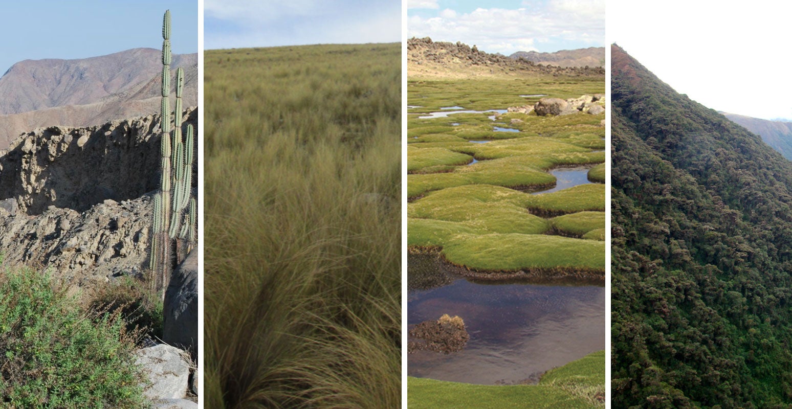
The Andes are known for their complex geography and climate, including steep slopes and unstable geology. Heavy rains are typical in the east, diminish toward the west and dry up almost entirely along the Pacific slopes. This unique environment is home to many rare plants and animals.

The pipeline’s path avoids critical habitats as much as possible but still crosses forests, shrublands, grasslands, and deserts that are home to more than 1,000 plant and animal species – some only known to live in areas near the pipeline.
During construction, the company made efforts to minimize environmental impacts. For example, they reduced the width of the right-of-way – the path along the pipeline’s route where people, machinery and materials travel – when critical habitats were crossed. Once the pipeline was buried and operational, a restoration program began, allowing native plants and animals to gradually return.
Evaluation and Analysis
When pipeline construction began, it was the standard for most biodiversity monitoring programs to focus on entire groups of plants or animals. For example, a program would focus solely on the mammal species in a study area. The Center for Conservation and Sustainability took a new approach, based on the mitigation hierarchy. The mitigation hierarchy is a set of guidelines designed to help development projects, like pipelines, achieve no net loss of biodiversity. It includes steps to avoid impacts, minimize those that can’t be avoided, and restore ecosystems so that biodiversity remains at a level equal to or greater than before a project began (no net loss of biodiversity).
Using this framework, CCS developed a hypothesis-driven Biodiversity Monitoring and Assessment Program specific to the pipeline’s path through the Andes. The research team identified 14 landscapes the pipeline crossed, each with a unique combination of plant life, water, geology and climate. Within each landscape, the team set recovery goals for species and habitats.
In a 2005 study, they identified 1,058 species of plants and animals native to the ecosystems crossed by the pipeline. In a complex setting like the Andes, monitoring this many species would not be possible. Instead, the team selected 145 species that could be sensitive to pipeline construction and operations.
In the early stages of the BMAP, they gathered data on the health and function of ecosystems in response to pipeline construction. More recently, they have studied how habitats are regaining their connectivity. The scientists continue to assess the pipeline’s impacts on a yearly basis to help guide the company’s restoration efforts.
Milestones
Question-driven biodiversity monitoring
CCS scientists asked company engineers and environmental managers what concerns they had about biodiversity. Based on those concerns, they devised questions that could be answered with scientific monitoring and selected key species or habitats to function as indicators of:
- the habitat fragmentation that resulted from the pipeline (pictured above) and
- the recovery of ecosystems affected during construction (pictured below)
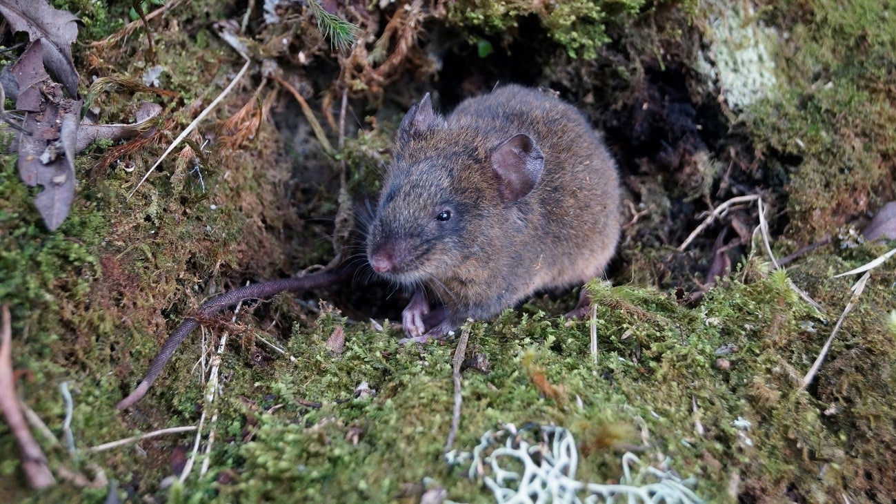
For example, the rodent communities in Andean grasslands include two endemic, rare cloud forest mouse species. During construction, all vegetation along the pipeline route was removed, and with it, the availability of shelter and food for the rodents. With time, native grasses recolonized the area and the rodent populations were reestablished.
The guiding principles of the BMAP included:
-
Clear objectives, questions, and conceptual models linking drivers of change (the factors responsible for inducing change, like land-use or pollution) and their effects on species or habitats
-
Replicable and peer-reviewed research protocols, adapted to the local environmental conditions. Protocols were also flexible, so they could be adjusted after each iteration of monitoring
-
Plans for data management, analysis and quality control
-
Helping the company interpret the results, so they can make informed decisions and meet their goals to restore habitat around the pipeline
Using natural processes to bring plants and animals back
Scientists learned that certain plants are important to the structural integrity of the humid, montane forests along the eastern slopes of the Andes. Their research showed that wild native rodents are key to dispersing the seeds of these plants. So, the company focused their early efforts on restoring plants that would offer food and shelter to these rodents. Once the rodents arrived, the seeds they dispersed from neighboring forests increased plant diversity and quickened the ecosystem’s recovery. This also helped reduce the timeline and costs of restoration efforts.
CCS’s long-term monitoring of plants across Andean ecosystems helped quantify the impact of avoidance, mitigation and restoration efforts around the pipeline. They continue to collect new data, which helps managers focus on areas in need of real-time attention, rather than investing resources in places that have recovered.
Collaborating with local researchers and training biodiversity scientists
More than 200 researchers supported the BMAP, most of them national researchers at different stages of their careers. CCS provided basic scientific training for local researchers who were just starting their careers. Alongside BMAP managers, these biodiversity scientists helped find innovative ways to translate technical results into language that company managers and engineers could easily understand.
Recommendations
1. Build a BMAP to reduce project risk and uncertainty and to measure the success of mitigation and monitoring efforts.
A BMAP can show which mitigation strategies are working at each step of a project, reducing its lasting impacts on the environment. The first phase of this BMAP focused on measuring the pipeline’s impact. The next phase focused on the restoration of different Andean landscapes. Using the wealth of data collected, researchers were able to create indexes to measure how well different types of habitat recovered over time. The BMAP measured the vital signs of the ecological system and provided adaptive management recommendations.
2. Nurture a strong and open relationship between researchers and company managers.
Ecological concerns and timeframes may diverge from engineering priorities. Scientists should share timely information and recommendations, so managers can make decisions that meet conservation and development goals. A united and integrated vision to achieve program goals is a win-win for conservation and sustainability.
3. Use BMAPs to fill gaps in knowledge about an area’s biodiversity.
Scientists gathered more than 10 years of biodiversity data during this project, allowing them to understand where species occur (or not), as well as increasing their knowledge of ecosystem composition, function and health. Biodiversity information from a BMAP can be used to understand the status of an ecosystem, identify impacts and detect trends.
4. Collaborate with local scientists and build capacity.
Local scientists often have knowledge of study sites that can add value. Many of the researchers CCS trained to work on this project later became lead researchers for the BMAP. Several went on to postgraduate studies, increasing Peru’s scientific capacity for the next generation of conservation and development professionals.