Case Study: Scenario Planning for Sustainable Development in Peru's Amazon Forest
Challenge
Madre de Dios, located in the foothills of Peru’s tropical Andes, is one of the most biodiverse places in the world. The region has renowned protected areas and initial land-use plans, which makes sustainable development a challenge. In 2014, a hydrocarbon company began gas exploration activities in Madre de Dios as part of the government’s economic development needs. The work overlapped a protected area, called the Amarakaeri Communal Reserve, and included several Indigenous territories.
There were concerns that energy exploration would open the area to illegal mining and deforestation. Local communities feared it would impact their forest and livelihoods. This case study explores how researchers from the Smithsonian Conservation Biology Institute’s Center for Conservation and Sustainability used scenario planning to help the company and regional government minimize social and environmental impacts in Madre de Dios and create a strategy for sustainable development.
Background
Madre de Dios is located within the Vilcabamba-Amboró conservation corridor, which connects about 74 million acres (30 million hectares) of wildlife habitat between Peru and Bolivia. The corridor is the most biologically diverse ecosystem in the world. Dividing Madre de Dios and the conservation corridor is the Interoceanic Highway, which connects ports on the Atlantic coast of Brazil to those on the Pacific coast of Peru.
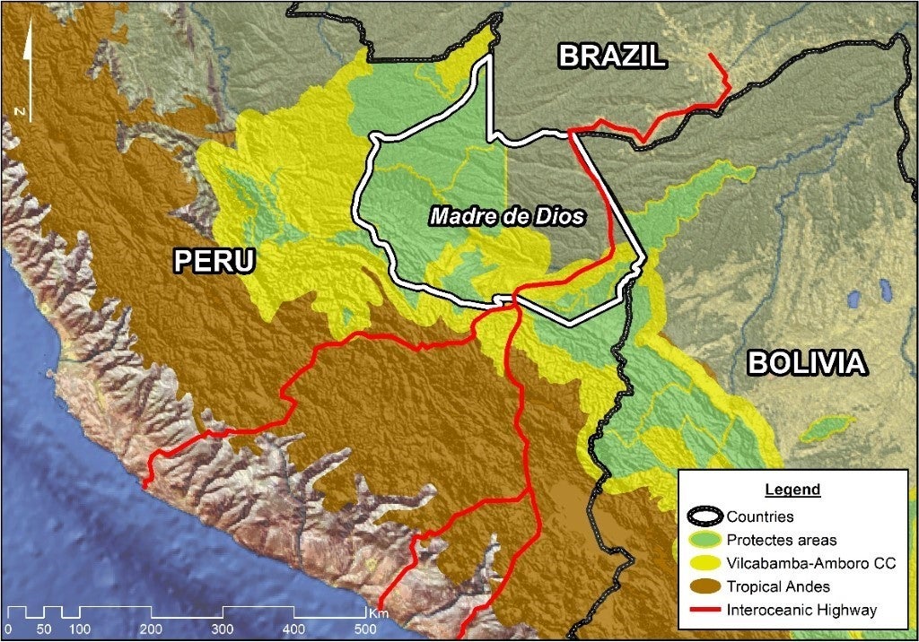
The road, completed in 2010, sped the transition of the regional economy from forest-based extractive industries (logging, Brazil nut harvesting, ecotourism, etc.) to agriculture, cattle production and gold mining. These changes promoted population growth. Today, Madre de Dios is home to about 150,000 people, including 14 native cultures, migrants from neighboring Andean regions, and immigrants from Brazil, Bolivia, and other countries.
Agriculture and gold mining are the main causes of deforestation in the area. The Amazon Forest covers more than 90% of Madre de Dios territory, of which about half is protected. The rest is divided into concessions for logging, hydrocarbon, mining, ecotourism and more.
Evaluation and Analysis
The Center for Conservation and Sustainability suggested a scenario planning approach to minimize the possible impact of the gas development field in Madre de Dios. Scenario planning is a structured way to think about the future of a region and facilitate decision making by exploring a handful of plausible futures, called scenarios. For this purpose, the CCS team needed to compare the economic, social and environmental success of different development scenarios. With more than 30 years of experience in Peru, CCS scientists were able to work with local stakeholders and the government to define a path forward.
When the exploratory drilling well produced no gas, the work ended. However, CCS continued to complete the scenario planning project for Madre de Dios to benefit sustainable development across the entire region (32,935 square miles or 85,301 square kilometers).
Creating sustainable landscapes requires managing roads and cities (gray infrastructure) that provide economic services with rivers and forests (green Infrastructure) that support biodiversity. Recognizing this, CCS developed the Working Landscape Simulator. The simulator combined state-of-the-art modeling with community engagement. It included seven steps:
- Assess the critical goods and services that people get from ecosystems (called ecosystem services) in Madre de Dios
- Develop qualitative scenarios about the future of the region with community participation
- Collect and generate quantitative data (demographic, economic, etc.)
- Model landscape changes, like deforestation and urbanization, for each scenario
- Evaluate economic, environmental and social indicators of success
- Develop lessons learned from the study
- Share the results
Models of land-use changes, such as trends in deforestation and urbanization, made the best use of the existing data. Engagement with local stakeholders ensured they were interested in the results and more likely to use them for decision making.
 performed better compared to the current trend scenario with no land-use plan (pictured next) in terms of levels of landowning conflicts, social indicators, surfaces reforested, deforestation, and pollution projected through 2040.")
 performed poorly compared to the planning scenario (pictured previously) in terms of levels of landowning conflicts, social indicators, surfaces reforested, deforestation, and pollution projected through 2040.")
Milestone Solutions
This study demonstrates that industrial operations, such as gas exploration, can contribute to sustainable development beyond traditional approaches and legal obligations. In scenario planning, CCS was able to provide:
- Collective recommendations that highlight the need for a land-use plan and provide a roadmap for planning regional land changes and sustainable development
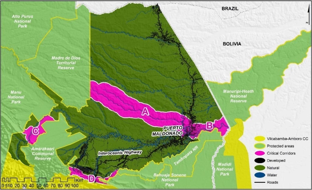
- Maps of critical conservation corridors and other areas that are key to keeping habitats connected within Madre de Dios.
- Essential and previously unavailable data – such as historical land cover maps; ecosystem services; and economic, social, and environmental indicators – needed to guide sustainable development and land-use planning.
Recommendations
The Center for Conservation and Sustainability’s study was key to understanding the conservation landscape of Madre de Dios and integrating that knowledge with the region's development needs. Best practices from this approach include:
- Consider scenario planning for large-scale projects to build a shared conservation and development vision
- Engage stakeholders early in the process
- Use high-quality models that track socioeconomic and ecosystem changes
- Develop various indicators of success in the three dimensions of sustainable development (economic prosperity, human wellbeing and environmental integrity)
- Share information by making methods and results publicly available to all
To learn more about the Madre de Dios scenario planning study download the “Future of Madre de Dios: Smithsonian’s Working Landscape Simulator for Sustainable Development” book.