First-of-its-Kind Digital Platform Reveals Migration Data for Birds Across the Western Hemisphere Just in Time for Fall Migration
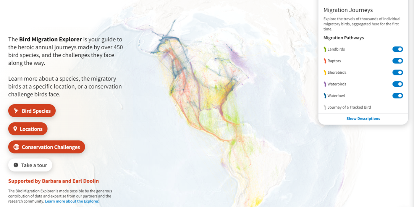
As millions of birds are flocking to their wintering grounds, the Smithsonian Migratory Bird Center and nine partner organizations announced today the Bird Migration Explorer, a state-of-the-art digital platform that reveals migration data consolidated for 458 bird species found in the United States and Canada. The free, interactive platform, available in English and Spanish, allows users to see the most complete data collected on migratory species in their neighborhoods and where those birds go throughout the year.
The Bird Migration Explorer reveals insights about the journeys of individual species, the connectedness, through migratory birds, of any given location in the hemisphere, and also details how migratory birds encounter 19 different conservation challenges. For example, at least 299 species connect New York City to at least 30 other countries and territories in the hemisphere, including places as far away as Argentina and Uruguay. And, the famous “River of Raptors" migration corridor in Veracruz, Mexico, is a hub connecting the extreme northern and southern ends of the globe.
The Bird Migration Explorer can also show when each of these species passes through New York, Veracruz, or any other location, and the extent to which each of those species overlaps with any number of conservation challenges such as light pollution or power lines along their journeys. More generally, a user can see how countries in the Americas are all connected to each other by migratory birds, underscoring the importance of international cooperation and collaboration in the research and conservation of these species.
Since 1970, North America has lost more than 2.5 billion migratory birds. By visualizing and highlighting the places birds need not only during breeding and wintering seasons, but also throughout the migratory periods in between, the Bird Migration Explorer provides a scientific basis for necessary conservation policies and solutions to address these steep declines.
The Bird Migration Explorer brings together three types of geospatial bird data: abundance data from Cornell Lab of Ornithology’s eBird Status models; connectivity data from the USGS Eastern Ecological Science Center Bird Banding Lab and Bird Genoscape Project; and tracking data from Birds Canada, the Smithsonian Migratory Bird Center and hundreds of researchers from across the globe, who generously contributed their datasets to this project. Audubon scientists and cartographers consolidated these data to create animated and interactive visualizations to bring species migration to life on a map.
The Bird Migration Explorer includes:
- Interactive, animated maps of the full annual migration for 458 species
- More than 4.2 million point-to-point migratory bird connections across the hemisphere
- Visualizations for 19 selected Conservation Challenges that migratory birds are exposed to throughout the year across the Americas.
The Bird Migration Explorer reflects an extraordinary partnership among science, conservation, and technology organizations and institutions and is made possible with data from the following partner organizations and more than 500 studies from researchers and institutions from around the world.
- Birds Canada
- Bird Conservancy of the Rockies
- Bird Genoscape Project
- BirdLife International
- Cornell Lab of Ornithology
- Esri
- Georgetown University
- Movebank
- National Audubon Society
- Smithsonian Migratory Bird Center
To learn more about migratory birds, the journeys they make, and the challenges they experience along the way, please visit the Bird Migration Explorer here: www.birdmigrationexplorer.org.
